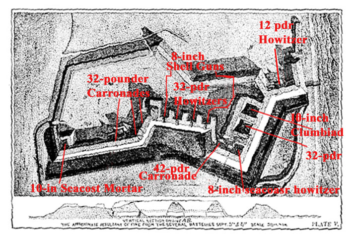

Plan of Fort Wagner, with overlay showing armament
- Date
- 1890
- Mapmaker / publisher
- U.S. War Department
- Place
- South Carolina in the American Civil War
- Archive
- Wikimedia Commons
- Type
- map
- Original size
- 711 × 476 pixels
Public domainsafest
Reason: a US government work.
Read from: Commons licence category: PD US Government; no CC BY, CC BY-SA, GFDL or deletion tag on the file page; permission field: Overlays are my own work and all rights are released (public domain).
Credit line
"Plan of Fort Wagner, with overlay showing armament" (1890). U.S. War Department, via Wikimedia Commons. Public domain. https://commons.wikimedia.org/wiki/File:00047CROPf.jpgNeed maps for a whole project? Add Find Any Map to Claude and ask for this one by its id: 541.
More like this

CHARLESTON MAP 3
Wikimedia Commons

Plan of Fort Fisher
1865 · Wikimedia Commons

Map showing siege operations against forts Sumter and Wagner, between July 13th & Sept. 7th, 1863, Maj. T. B. Brooks, A.D.C. & Assist. Engrs. Published by permission of Genl. Gillmore at the U.S.
1863 · Library of Congress

Plan of Genl Q. A. Gillmore's position on Morris Island, Charleston S.C.
1861 · Library of Congress

Plan of the assault on Ft. Wagner, July 11th 1863.
July 11, 1863 · Library of Congress

Fort Wagner. Morris Island
1863 · Library of Congress

(Plan of Fort Sumter, South Carolina) - surveyed, March 20th, 22, 27, 1865.
1865 · Library of Congress

Charleston Harbor and its Approaches Showing the positions of the Rebel Batteries, 1863 and annotated to show the status of the siege of the city, July 17, 1863
1863 · U.S. National Archives