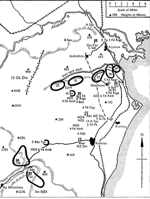

NZ Division positions Aliakmon
NZ Division sector of the Aliakmon Line, 5 April 1941
- Date
- 1963
- Mapmaker / publisher
- Lands and Survey Department, New Zealand
- Archive
- Wikimedia Commons
- Type
- map
- Original size
- 492 × 654 pixels
Public domain
Reason: public domain: New Zealand.
This status rests on the map's publication history, as researched by Wikimedia Commons. Check it before commercial use.
Read from: Commons licence category: PD-New Zealand; no CC BY, CC BY-SA, GFDL or deletion tag on the file page.
Credit line
"NZ Division positions Aliakmon" (1963). Lands and Survey Department, New Zealand, via Wikimedia Commons. Public domain. https://commons.wikimedia.org/wiki/File:NZ_Division_positions_Aliakmon.pngNeed maps for a whole project? Add Find Any Map to Claude and ask for this one by its id: 23981.
More like this

New Zealand Divisional Cavalry Positions in Crete
1963 · Wikimedia Commons

Allied Advance to Florence August 1944
1963 · Wikimedia Commons

Map of battle of Kleisoura Pass, April 1941
1941 · Wikimedia Commons

The battle of Doiran. Night attack of Entente forces on 24th April 1917
1935 · Wikimedia Commons

The battle of Doiran. Night attack of Entente forces on 8th May 1917
1935 · Wikimedia Commons

Operations at the border of Greece and Serbia, 1916. his map was created by the Department of Military Art and Engineering, at the U.S. Military Academy (West Point). The initial version was created u
1959 · Wikimedia Commons

Allied Advance Across Owen Stanley Range 1942
1957 · Wikimedia Commons

Sketch Map showing area of British attack along Achi Baba Nullah, Gallipoli peninsula, 12 July 1915, including trench lines.
1921 · Wikimedia Commons