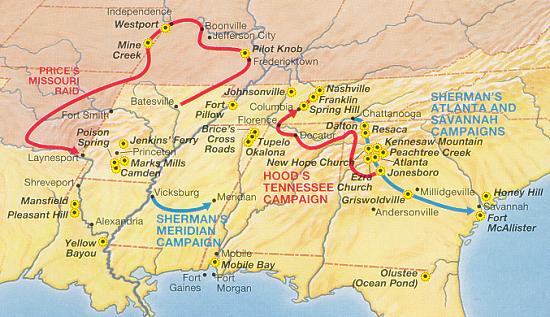

NPS CW at a Glance Western 1864
Operations in the American Civil War, 1864
- Date
- 1864
- Mapmaker / publisher
- NPS Graphics
- Place
- the Southern United States
- Archive
- Wikimedia Commons
- Type
- map
- Original size
- 550 × 317 pixels
Public domainsafest
Reason: a US government work (NPS).
Read from: Commons licence category: PD US NPS; no CC BY, CC BY-SA, GFDL or deletion tag on the file page.
Credit line
"NPS CW at a Glance Western 1864" (1864). NPS Graphics, via Wikimedia Commons. Public domain. https://commons.wikimedia.org/wiki/File:NPS_CW_at_a_Glance_Western_1864.jpgNeed maps for a whole project? Add Find Any Map to Claude and ask for this one by its id: 872.
More like this

Operations in the Eastern Theater of the American Civil War, 1864
1864 · Wikimedia Commons

Operations in the Eastern Theater of the American Civil War, 1865
1865 · Wikimedia Commons

Civil War campaigns of 1864
1864 · Library of Congress

Map of Kentucky and Tennessee.
1864 · Library of Congress

Map showing the operations of the national forces under the command of Maj. Gen. W.T. Sherman during the campaign resulting in the capture of Atlanta, Georgia, Sept. 1, 1864
May 6, 1864 · Library of Congress

Plan of the western seat of war.
1865 · Library of Congress

Hazard's rail road & military map of the southern states.
1864 · Library of Congress

Map of the Fall 1864 Campaign of the Army of Missouri, Major Gen. Sterling Price Commanding
1861–1876 · Page 1