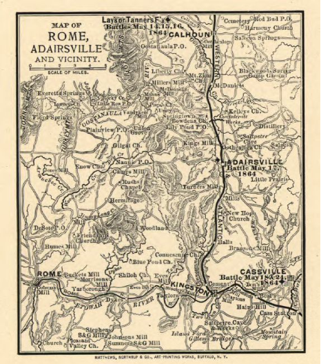

Map of Rome and Adairsville 1864
Map from 1864 shows the Western and Atlantic Railroad as well as part of northern Georgia, including Calhoun, Adairsville, Rome, Kingston, and Cassville.
- Date
- 1864
- Mapmaker / publisher
- "Map of Rome, Adairsville and vicinity". Published: Buffalo, N.Y., Matthews, Northrup & Co., Art-Printing Works, 1864
- Place
- Rome, Georgia
- Archive
- Wikimedia Commons
- Type
- map
- Original size
- 466 × 528 pixels
Public domainsafest
Reason: its US copyright has expired (published before 1931).
Read from: Commons licence category: PD US expired; no CC BY, CC BY-SA, GFDL or deletion tag on the file page.
Credit line
"Map of Rome and Adairsville 1864" (1864). "Map of Rome, Adairsville and vicinity". Published: Buffalo, N.Y., Matthews, Northrup & Co., Art-Printing Works, 1864, via Wikimedia Commons. Public domain. https://commons.wikimedia.org/wiki/File:Map_of_Rome_and_Adairsville_1864.pngNeed maps for a whole project? Add Find Any Map to Claude and ask for this one by its id: 1247.
More like this

Map of Rome, Adairsville and vicinity
1864 · Library of Congress

Map of army operations Atlanta campaign between Cassville and Mariette and vicinity
1864 · Library of Congress

Map showing Genl. Sherman's march from Chattanooga to Atlanta.
1864 · Library of Congress

Map of army operations Atlanta campaign between Kingston and Atlanta
1864 · Library of Congress

Birds-eye map of the Western and Atlantic R.R., the great Kennesaw route; Army operations, Atlanta campaign, 1864.
1887 · Library of Congress

Map of Atlanta and vicinity
1864 · Library of Congress

Map of the Atlanta campaign. (May-Sept. 1864).
1887 · Library of Congress

Map of Resaca and vicinity. (1864)
1864 · Library of Congress