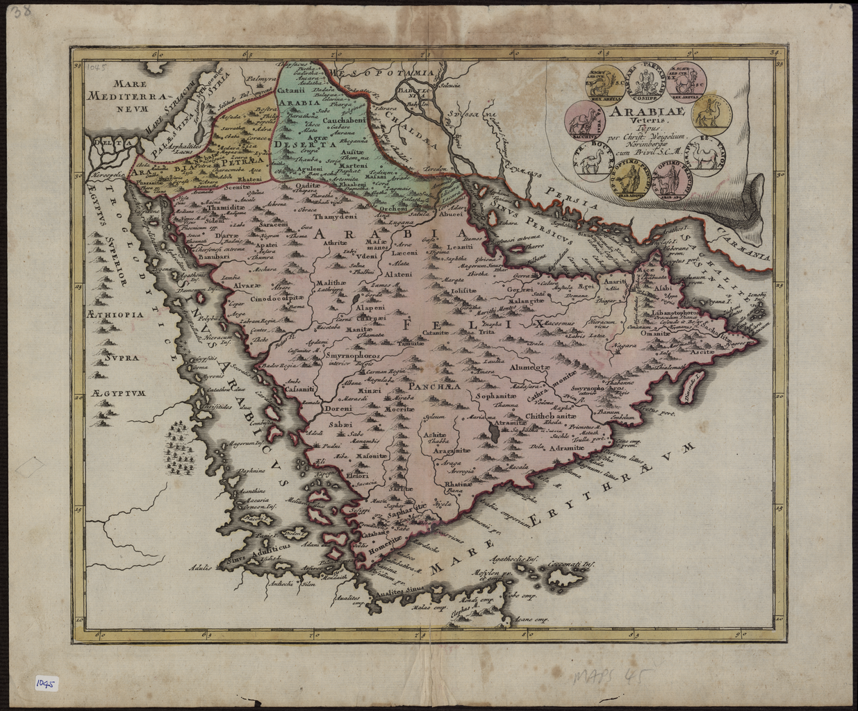

Map of Ancient Arabia
This map of the Arabian Peninsula, published in 1720, shows Arabia Felix, Arabia Deserta, and Arabia Petraea. Other regions included are Palestine, Mesopotamia, Chaldea, Persia, Aegyptus, and Aethiopia. A large number of towns are shown. The title cartouche includes nine vignette coins. The tribal and town names on the map are those used by Ptolemy. Some are used more than once, with variations. Thus “Indicara,” “Iacara,” “Ichara,” and “Aphana” all could indicate the same place: the spot where Alexander the Great intended to build a capital on an island in the Arabian Gulf, enabling him to control the trade of the region and extend his empire (a scheme that he was unable to accomplish before he died). Archeological research suggests that this place was Failakah Island in present-day Kuwait, although some historians place it at Abu Ali Island. The map shows a peninsula near present-day Bahrain. The islands of “Arathos” and “Thylaso” indicate Muharraq and Bahrain islands, respectively, which are actually located north of Qatar. On this map, they are placed on the Persian coast side, probably because the cartographer confused them with “Hormuz” and “Qishm.” Qatar is mentioned on the m
- Date
- 1720
- Mapmaker / publisher
- Weigel, Christoph (1654-1725)
- Place
- Arabia
- Archive
- Wikimedia Commons
- Type
- map
- Original size
- 1,235 × 1,024 pixels
Public domainsafest
Reason: its maker died more than 100 years ago, and a faithful scan of a flat work adds no new copyright.
Read from: Commons licence category: PD-Art (PD-old-100); no CC BY, CC BY-SA, GFDL or deletion tag on the file page.
Credit line
"Map of Ancient Arabia" (1720). Weigel, Christoph (1654-1725), via Wikimedia Commons. Public domain. https://commons.wikimedia.org/wiki/File:Map_of_Ancient_Arabia_WDL2923.pngNeed maps for a whole project? Add Find Any Map to Claude and ask for this one by its id: 240696.
More like this

A Current and Correct Depiction of Arabia Felix, Arabia Petraea, and Arabia Deserta
1658 · Wikimedia Commons

Map of Arabia
1662 · Wikimedia Commons

This map of 1616, with Latin place names, is a reprint of a work by Jodocus Hondius (1563-1612), a Flemish cartographer and engraver who settled in Amsterdam in about 1593 and established a business t
1616 · Wikimedia Commons

Arabiae Felicis, Petrae ae et desertae nova et accurata delineatio
1673–1719 · Wikimedia Commons

Carte deL'Arabie qui se divise en Arabie Petree, Deserte et Heureuse, Projettee en assujettie aux Observations Celestes.
1771 · Wikimedia Commons

Cartes generales de toutes les parties du monde, ou les empires, monarchies, republiques, estats, peuples, &c. de l'Asie, de l'Afrique, de l'Europe, & de l'Americque, tant anciens que nouveaux, sont exactement remarqués, & distingués suivant leur estendue. Par le Sieur Sanson d'Abbeville, Geographe
1658 · Arabia, plate 29 of 388

This 1616 map is a reprint of a map originally published in 1598 by Jodocus Hondius (1563-1612), a Flemish cartographer and engraver who settled in Amsterdam in about 1593 and established a business t
1598 · Wikimedia Commons

Map of Arabia, 1719
1683–1719 · Wikimedia Commons