

خريطة إمارة بوشهر
Map of the Emirate of Bushehr. Source:History of the Arab Tribes on the Persian Coasts. pp.58–60. The map was modified from this image: link
- Mapmaker / publisher
- Reiser115
- Place
- Iran
- Archive
- Wikimedia Commons
- Type
- map
- Original size
- 720 × 859 pixels
CC0safest
Reason: CC0: dedicated to the public domain.
Read from: Commons licence category: CC-Zero; no CC BY, CC BY-SA, GFDL or deletion tag on the file page.
Credit line
"خريطة إمارة بوشهر". Reiser115, via Wikimedia Commons. CC0. https://commons.wikimedia.org/wiki/File:%D8%AE%D8%B1%D9%8A%D8%B7%D8%A9_%D8%A5%D9%85%D8%A7%D8%B1%D8%A9_%D8%A8%D9%88%D8%B4%D9%87%D8%B1.jpgNeed maps for a whole project? Add Find Any Map to Claude and ask for this one by its id: 241759.
More like this

Map of the Arabian Peninsula and Persian Gulf in 1829
1832 · Wikimedia Commons

A large draught of the golf of Persia
1700–1799 · Wikimedia Commons
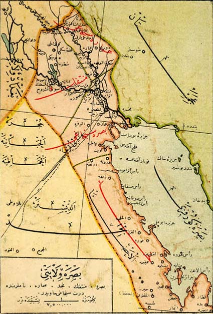
Vilayet of Basra, early 20th century
1918 · Wikimedia Commons

Carte de la Coste d'Arabie, Mer Rouge, et Golfe de Perse
1745–1746 · Wikimedia Commons

Map of the Persian Gulf DSCF0066
Wikimedia Commons

IslamicConquestsIroon-ar
Wikimedia Commons

Carte Du Golphe Persique
1763 · Wikimedia Commons

Carte du Golphe Persique
Wikimedia Commons