

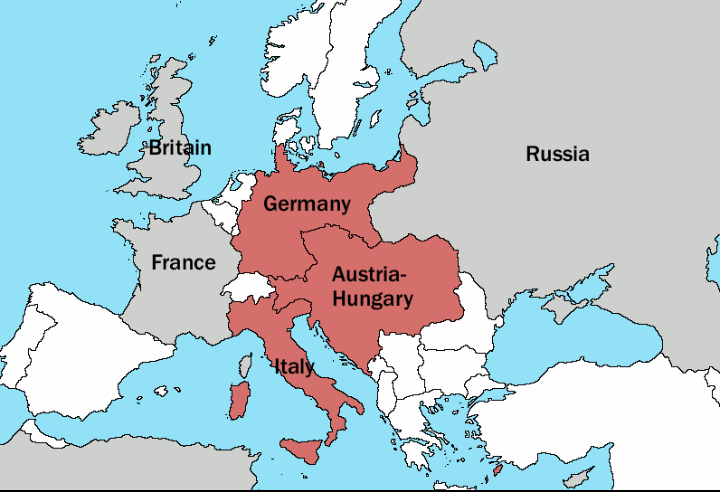
Map 1914 WWI Alliances
Map of Europe's alliances in 1915. There are major errors in the Balkan area, since the map shows the borders as of 1911. After the Balkan Wars the borders changed significantly. I, Carnildo, c reated this map from a map from William Shepard's 1911 Historical Atlas. The original map was downloaded from the University of Texas' Perry-Castañeda Library map collection, URL The GIMP-native image file for this image may be found at:en:Image:Europe-WWI.xcf. It is recommended that anyone editing this map work with the.xcf version.
- Date
- November 6, 2005
- Place
- Lithuania
- Archive
- Wikimedia Commons
- Type
- map
- Original size
- 1,682 × 1,328 pixels
Public domain
Reason: public domain: self.
This status rests on the map's publication history, as researched by Wikimedia Commons. Check it before commercial use.
Read from: Commons licence category: PD-self; no CC BY, CC BY-SA, GFDL or deletion tag on the file page.
Credit line
"Map 1914 WWI Alliances" (November 6, 2005). Wikimedia Commons. Public domain. https://commons.wikimedia.org/wiki/File:Map_1914_WWI_Alliances.jpgNeed maps for a whole project? Add Find Any Map to Claude and ask for this one by its id: 22429.
More like this

Europe 1914
1914 · Wikimedia Commons

Europe 1914
1914 · Wikimedia Commons

C. 1911 Europe and Russia
c. 1911 · Wikimedia Commons

أوروبل-1914
1914 · Wikimedia Commons
Triple Alliance
February 27, 2007 · Wikimedia Commons

Europe 1914 bg
September 21, 2007 · Wikimedia Commons

Europe 1914 Shepherd
1926 · Wikimedia Commons

Avrupa 1914
1914 · Wikimedia Commons