

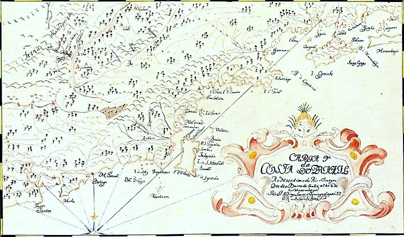
Livro que dá Razão do Estado do Brasil, 1612 - Serra das Esmeraldas
Facsimile of the 1612 manuscript Livro que dá Razão do Estado do Brasil, attributed to Diogo de Campos Moreno, containing descriptions and maps of the State of Brazil in the early 17th century. The maps are attributed to João Teixeira Albernaz I.
- Date
- 1612
- Place
- Brazil
- Archive
- Wikimedia Commons
- Type
- map
- Original size
- 2,509 × 1,177 pixels
Public domainsafest
Reason: its maker died more than 100 years ago.
Read from: Commons licence category: PD-old-100-expired; no CC BY, CC BY-SA, GFDL or deletion tag on the file page.
Credit line
"Livro que dá Razão do Estado do Brasil, 1612 - Serra das Esmeraldas" (1612). Wikimedia Commons. Public domain. https://commons.wikimedia.org/wiki/File:Livro_que_d%C3%A1_Raz%C3%A3o_do_Estado_do_Brasil,_1612_-_Serra_das_Esmeraldas.jpgNeed maps for a whole project? Add Find Any Map to Claude and ask for this one by its id: 141637.
More like this

Livro que dá Razão do Estado do Brasil, 1612 - Capitania do Espírito Santo
1612 · Wikimedia Commons

Course of the São Francisco River and the Navigation Along It from São Paulo to the Pitangui Mines
1700 · Wikimedia Commons

Taboas geraes de toda a navegação
1630 · Plate 23

Description of the coast from Rio de Janeiro to the port of São Vicente
1612 · Wikimedia Commons

Map of the Region of Minas Gerais with a Part of the Way from São Paulo and of Rio de Janeiro to the Mines, Showing Tributaries of the São Francisco River
1700–1799 · Wikimedia Commons

Atlas nautique portugais
1558 · Brazil, plate 13 of 16
Map of the Brazilian coast from Santos to Marambaia
1729 · Wikimedia Commons

Valença Mapa do Sertão por Inácio de Sousa Vernek
c. 1800 · Wikimedia Commons