

Italian Empire 2.0
- Date
- July 28, 2024
- Mapmaker / publisher
- Real293
- Place
- the Italian Empire
- Archive
- Wikimedia Commons
- Type
- map
- Original size
- 2,000 × 2,000 pixels
CC0safest
Reason: CC0: dedicated to the public domain.
Read from: Commons licence category: CC-Zero; no CC BY, CC BY-SA, GFDL or deletion tag on the file page.
Credit line
"Italian Empire 2.0" (July 28, 2024). Real293, via Wikimedia Commons. CC0. https://commons.wikimedia.org/wiki/File:Italian_Empire_2.0.pngNeed maps for a whole project? Add Find Any Map to Claude and ask for this one by its id: 24520.
More like this

Italian Empire in 1939
October 30, 2025 · Wikimedia Commons

Map of Italian "Mare Nostrum" (Italian Mediterranean), showing inside the green line & dots the italian areas in the Mediterranean sea during summer 1942 (in red those under British control). The rema
2007 · Wikimedia Commons
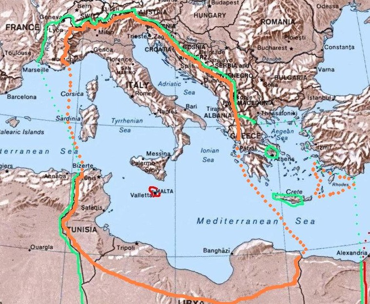
Map of the 1940 project "Imperial Italia", inside the orange line and dots, in Europe and North Africa. Self-made (I have based my work on the original Commons Image:Mediterranean Relief.jpg, licensed
2008 · Wikimedia Commons

Italy and Possessions September 1939
June 29, 2008 · Wikimedia Commons

Roman Empire full map
Wikimedia Commons

Italian Somaliland, Horn of africa, scramble for africa 1900s
November 19, 2021 · Wikimedia Commons

Italian empire 1914
October 31, 2007 · Wikimedia Commons

Roman Empire
1907 · Wikimedia Commons