

Horn1915ad fin
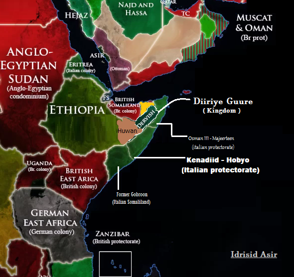
Horn of Africa, c. 1915 C.E. according to contemporary sources. Page 28 of the "memoirs of general lord ismay" describes an eastern front from Ankhor, to Eil Dur Elan (Dhur Cilaan), to Badwein, and then a southwest line to the 46th longitude line, and negating mentioning the presence of a southern front. Map of the 46th meridian can be found here. A source of dervishes expanding south towards Beledweyne can be found here: regions north and west of Jidali are shaded due to the page 421 statement from Lieutenant-Colonel H. Moyse-Bartlett in the King's African Rifles (Volume 2) that "Warsangeli had now broken with the Mullah" and that "The nearest dervish post was now at Jidali, which would have been attacked in May but for a Turkish threat to Aden", indicating neither British nor dervish dominance over the area between Ankhor and Jidali.
- Date
- 2008
- Mapmaker / publisher
- Ingoman, Jusba v
- Place
- the Italian Somaliland
- Archive
- Wikimedia Commons
- Type
- map
- Original size
- 500 × 599 pixels
Public domain
Reason: public domain: self.
This status rests on the map's publication history, as researched by Wikimedia Commons. Check it before commercial use.
Read from: Commons licence category: PD-self; no CC BY, CC BY-SA, GFDL or deletion tag on the file page.
Credit line
"Horn1915ad fin" (2008). Ingoman, Jusba v, via Wikimedia Commons. Public domain. https://commons.wikimedia.org/wiki/File:Horn1915ad_fin.pngNeed maps for a whole project? Add Find Any Map to Claude and ask for this one by its id: 24524.
More like this
1915 ww1 - Idrisid Asir, Gobroon, Kenadiid & Diiriye Guure kingdom
October 8, 2021 · Wikimedia Commons

Somali lands in 1930
1930 · Wikimedia Commons

Horn of Africa and Southwest Arabia - Mid-1930s
1991 · Wikimedia Commons

Italian Somalia 1900s
November 19, 2021 · Wikimedia Commons

Horn of Africa.
2009 · Library of Congress

A map of the French, British, Italian, and Abyssinian i.e., Ethiopian Somalilands i.e., Somalia and Djibouti c. 1911.
1911 · Wikimedia Commons

East Africa WWI as at August 1915
1915 · Wikimedia Commons

Italian Somaliland, Horn of africa, scramble for africa 1900s
November 19, 2021 · Wikimedia Commons