

HD 188753
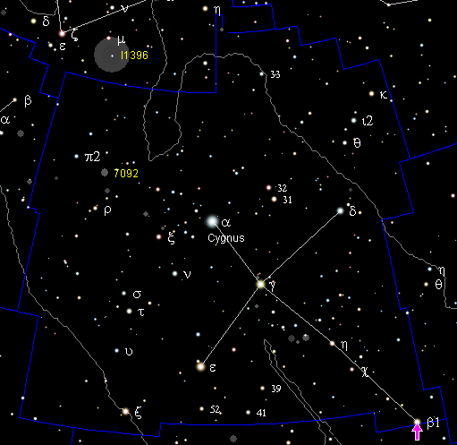
This is a finding chart for HD 188753. It was created using the program MegaStar, version 4.0, on 2005-July-17. HD 188753 is indicated by the crosshairs in the middle. The dashed red lines are constellation boundaries, the solid red line is the ecliptic. All coordinates refer to equinox 2000.0. The field is 30° across, with lines of right ascension and declination in dark grey every 40 min of R.A. and every 5° of dec. The north pole is to the top. The:en:North American nebula is visible (top left), and so is the:en:Veil nebula (bottom left). The green filled circles and the grey hollow circles are non-stellar objects (Messier, NGC, etc.).
- Date
- July 17, 2005
- Archive
- Wikimedia Commons
- Type
- map
- Original size
- 879 × 675 pixels
Public domain
Reason: public domain: self.
This status rests on the map's publication history, as researched by Wikimedia Commons. Check it before commercial use.
Read from: Commons licence category: PD-self; no CC BY, CC BY-SA, GFDL or deletion tag on the file page.
Credit line
"HD 188753" (July 17, 2005). Wikimedia Commons. Public domain. https://commons.wikimedia.org/wiki/File:HD_188753.pngNeed maps for a whole project? Add Find Any Map to Claude and ask for this one by its id: 104297.
More like this

Hd101930
October 16, 2006 · Wikimedia Commons

Ophiuchus constellation map ru lite
October 17, 2006 · Wikimedia Commons

Norma constellation map ru lite
October 16, 2006 · Wikimedia Commons

Perseus constellation map ru lite
March 11, 2007 · Wikimedia Commons

Triangulum Australe constellation map ru lite
February 19, 2007 · Wikimedia Commons

Pegasus constellation map ru lite
February 25, 2007 · Wikimedia Commons

Sagitta constellation map ru lite
February 21, 2007 · Wikimedia Commons
Position beta Cyg
December 15, 2004 · Wikimedia Commons