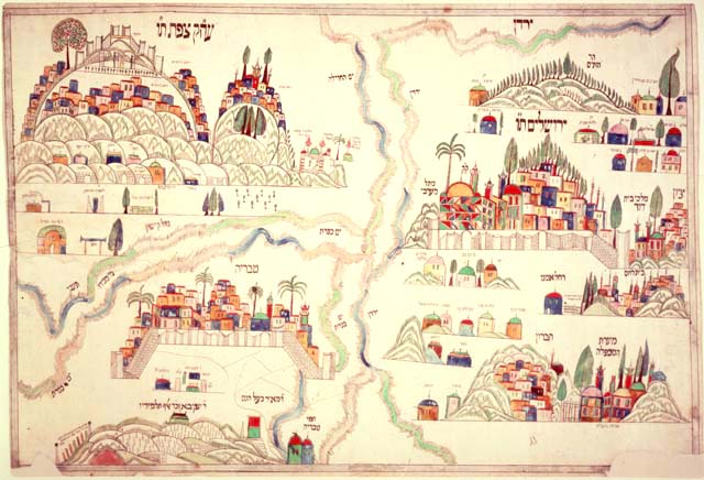

Four holy cities plaque
Holy Cities Plaque (Palestine, nineteenth century). Depicting the four Holy Cities of the Holy Land, this plaque is divided into four quadrants, with Jerusalem occupying by far the largest area in the upper right quadrant. Below Jerusalem, is Hebron. Dividing the drawing roughly down the center is the Jordan River. In the top left quadrant -- higher even than Jerusalem -- is Safed; and directly below it, we find Tiberias. Each of the four cities includes representations of the sacred shrines, as well as the graves of sainted rabbis and holy men.
- Place
- Jerusalem
- Archive
- Library of Congress (via Wikimedia Commons)
- Type
- map
- Original size
- 640 × 436 pixels
Public domain
Reason: its maker died more than 100 years ago.
This status rests on the map's publication history, as researched by Wikimedia Commons. Check it before commercial use.
Read from: Commons licence category: PD-old-100-expired; no CC BY, CC BY-SA, GFDL or deletion tag on the file page.
Credit line
"Four holy cities plaque". Library of Congress, Geography and Map Division, via Wikimedia Commons. Public domain. https://commons.wikimedia.org/wiki/File:Four_holy_cities_plaque.jpgNeed maps for a whole project? Add Find Any Map to Claude and ask for this one by its id: 241865.
More like this

Bird's Eye View of the Holy Land
Wikimedia Commons

Novae Ierosolymae et locorum circumiacentium accurata imago
1639 · Wikimedia Commons

IERUSALEM EN SYN TEMPEL
1687 · Wikimedia Commons

Sabulon and Neptalim. Willem Janszoon Blaeu and Joan Blaeu. Terra Sancta quae in Sacris Terra Promissionis olim Palestina. 1648-1664
1648–1664 · New York Public Library

Ierusalem- described as it stoode in greatest beautie the cheife places & Actions obserued with a chronology from the first Erection to the last Ruins.
Wikimedia Commons

Terra Sancta quae in sacris Terra Promissionis olim Palestina
Wikimedia Commons

HOLY LAND Gerard de Jode. Speculum Orbis Terrarum
1578 · Wikimedia Commons

Iherusalem Turcis Cusembareich. Nazareth. Ramma
1657 · Wikimedia Commons