

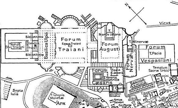
EB1911 Rome - Imperial Fora
Map of the fora of the Roman Empire in Rome.
- Date
- 1911
- Mapmaker / publisher
- From Richter's Topographie der Stadt Rom by permission of C. H. Beck'sche Verlagsbuchhandlung
- Place
- ancient Rome
- Archive
- Wikimedia Commons
- Type
- map
- Original size
- 1,746 × 806 pixels
Public domain
Reason: public domain: Britannica.
This status rests on the map's publication history, as researched by Wikimedia Commons. Check it before commercial use.
Read from: Commons licence category: PD Britannica; no CC BY, CC BY-SA, GFDL or deletion tag on the file page.
Credit line
"EB1911 Rome - Imperial Fora" (1911). From Richter's Topographie der Stadt Rom by permission of C. H. Beck'sche Verlagsbuchhandlung, via Wikimedia Commons. Public domain. https://commons.wikimedia.org/wiki/File:EB1911_Rome_-_Imperial_Fora.jpgNeed maps for a whole project? Add Find Any Map to Claude and ask for this one by its id: 20204.
More like this

EB1911 Rome - The Roman Forum and the Sacra Via (left)
1911 · Wikimedia Commons

EB1911 Rome - The Roman Forum and the Sacra Via (right)
1911 · Wikimedia Commons

Map of downtown Rome during the Roman Empire large
1916 · Wikimedia Commons

# Plan of the Roman Forum and its Vicinity at the Time of the Republic # Plan of the Imperial Forums and their Vicinity Historical Atlas by William R. Shepherd, 1911. Courtesy of the University of Tex
1910s · Wikimedia Commons

The Topography and Monuments of Ancient Rome cropped
1911 · Wikimedia Commons
Foramap
Wikimedia Commons

Map of Imperial Rome by William R Shepherd (died 1934)
1934 · Wikimedia Commons

Forum map - Regia
1916 · Wikimedia Commons