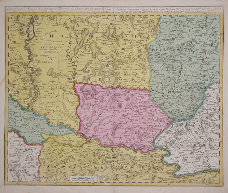

Copper engraving, hand colored in outline and wash when published. This map shows southern parts of the Habsburg Kingdom of Hungary with the neighboring Ottoman Province of Temeşvar, the southwestern
- Date
- 1700
- Mapmaker / publisher
- Schenk, Petrus
- Place
- Hungary
- Archive
- Wikimedia Commons
- Type
- map
- Original size
- 737 × 623 pixels
Public domainsafest
Reason: its maker died more than 100 years ago, and a faithful scan of a flat work adds no new copyright.
Read from: Commons licence category: PD-Art (PD-old-100); no CC BY, CC BY-SA, GFDL or deletion tag on the file page; permission field: old map.
Credit line
"Copper engraving, hand colored in outline and wash when published. This map shows southern parts of the Habsburg Kingdom of Hungary with the neighboring Ottoman Province of Temeşvar, the southwestern " (1700). Schenk, Petrus, via Wikimedia Commons. Public domain. https://commons.wikimedia.org/wiki/File:Banat1700.jpgNeed maps for a whole project? Add Find Any Map to Claude and ask for this one by its id: 297089.
More like this

Neu-Geographisch vorgestelltes Ungarisches Kriegs-Theatrum in Servien une dem Bannat Temeswar
1717 · 2 sheets

Regni Hungariae, Graeciae, Moreae, totius Danubii, adiacentiumque regnorum nec non totius Graeciae et archipelagi, delineatio nova
c. 1700 · Wikimedia Commons

Ca. 1720 map of the Balkans by Peter Schenk
c. 1720 · Wikimedia Commons

Theatrum belli sive novissima tabula, qua maxima pars Danubii et praesertim Hungaria cum aliis adiacentibus regnis
1730–1760 · Wikimedia Commons

Hungaria universalis divisa in proprie dictam Hungariam principatum septimonti regiones Sclavoniae Croatiae Bosniae Moldaviae Valachiae Bessarabiae et Romaniae
c. 1710 · Wikimedia Commons

Neu Geographisch vorgestelltes Ungarisches Kriegs-Theatrum in Servien und dem Bannat Temeswar
1716 · Johann Baptist Homann

Nova totius Hungariae, Transilvaniae, Serviae, Romaniae, Bulgariae, Walachiae, Moldaviae, Sclavoniae, Croatiae, Bosniae, Dalmatiae, maximaeq ue partis Danubii fluminis, descriptio
c. 1680 · Wikimedia Commons

Regni Hungariae, Graeciae, Moreae, totius Danubii, adiacentiumque regnorum nec non totius Graeciae et archipelagi, delineatio nova
Wikimedia Commons