

Bouillet - Atlas universel, Carte 76
- Place
- South Asia
- Archive
- Wikimedia Commons
- Type
- atlas page
- Original size
- 2,674 × 1,691 pixels
Public domain
Reason: its maker died more than 100 years ago.
This status rests on the map's publication history, as researched by Wikimedia Commons. Check it before commercial use.
Read from: Commons licence category: PD-old-100-expired; no CC BY, CC BY-SA, GFDL or deletion tag on the file page.
Credit line
"Bouillet - Atlas universel, Carte 76". Wikimedia Commons. Public domain. https://commons.wikimedia.org/wiki/File:Bouillet_-_Atlas_universel,_Carte_76.pngNeed maps for a whole project? Add Find Any Map to Claude and ask for this one by its id: 243329.
More like this

The royal illustrated atlas of modern geography / with an introductory notice by Dr N. Shaw, secretary of the royal geographical society
1863 · Asia, plate 278 of 404

Nouvel atlas des colonies françaises
1891 · India

Atlas élémentaire portatif: pour servir à l'étude de la géographie ancienne et moderne, et à celle de l'histoire
2 sheets

Vollständiger Hand-Atlas der neueren Erdbeschreibung über alle Theile der Erde in 82 Blättern
Wikimedia Commons

From 'The Imperial Atlas of Modern Geography' by Blackie and Son, London, 1860 (drawn by J. and C. Walker)
1860 · Wikimedia Commons

India or Hindostan.
1855 · Wikimedia Commons
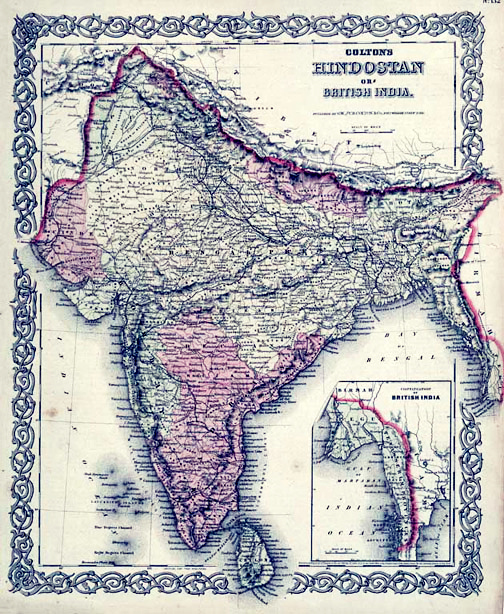
Map of British India, 1855. Published by G. W. and C. B. Colton and Company in New York, 1855. It was derived from an earlier wall map of the world produced by Colton and D. Griffing Johnson. Covers t
1855 · Wikimedia Commons

Atlas Universel de Geographie construit d'après les sources originales et les documents les plus récents, cartes, voyages, mémoires, travaux géodésiques, etc.: nouvelle édition conforme aux traités de paix de 1919-1921 (Nouvelle édition conforme aux traités. de 1919-1922) / par M. Vivien de Sain
1919–1922 · Asia, plate 227 of 369