

Bombay Island map 1893
map of Island of Bombay Mumbai Bombay and western india by James Douglas Published 1893 Page 15 Scanningcentre Ccl,Hyderabad Numeric_id 73662 Identifier BombayAndWesternIndia Type Text Collectionid BombayAndWesternIndia Public_date 2003-11-21 09:24:58
- Date
- 1893
- Mapmaker / publisher
- James Douglas
- Place
- Mumbai
- Archive
- Wikimedia Commons
- Type
- map
- Original size
- 1,094 × 1,978 pixels
Public domain
Reason: public domain: India.
This status rests on the map's publication history, as researched by Wikimedia Commons. Check it before commercial use.
Read from: Commons licence category: PD India; no CC BY, CC BY-SA, GFDL or deletion tag on the file page.
Credit line
"Bombay Island map 1893" (1893). James Douglas, via Wikimedia Commons. Public domain. https://commons.wikimedia.org/wiki/File:Bombay_Island_map_1893.pngNeed maps for a whole project? Add Find Any Map to Claude and ask for this one by its id: 255826.
More like this
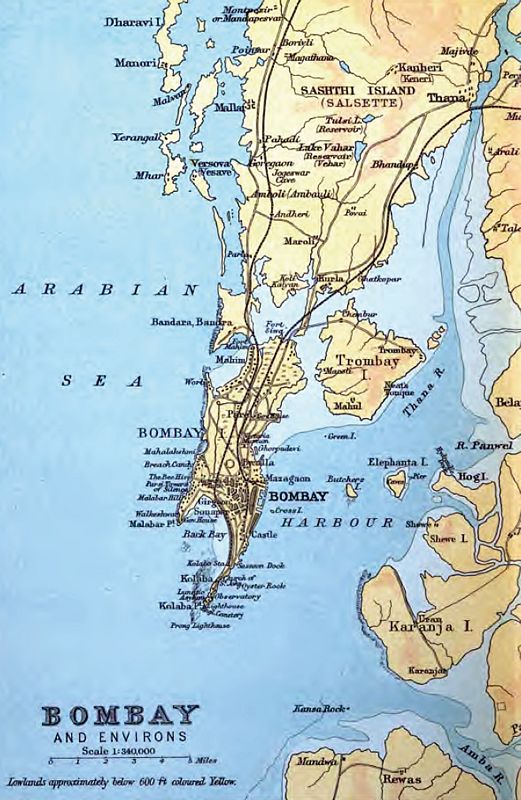
This is an 1893 map of the original islands of Bombay before they were merged to form the present-day geographic entity.
1893 · Wikimedia Commons

Bombay City map
1893 · Wikimedia Commons

Map of the Island of Bombay from The Imperial Gazetteer of India (1907-1909)
1907–1909 · Wikimedia Commons

Bombay 1903
1903 · Wikimedia Commons

Bombay, A map from 'The Earth and Its Inhabitants' by Elisee Reclus, 1883
1883 · Wikimedia Commons

Bombay From "The Royal Atlas of Modern Geography" by Alexander Keith Johnston (William Blackwood & Sons, Edinburgh & London, 1861)
1861 · Wikimedia Commons

Map of the City of Bombay from The Imperial Gazetteer of India (1907-1909)
1907–1909 · Wikimedia Commons

Bombay 1909
1909 · Wikimedia Commons