

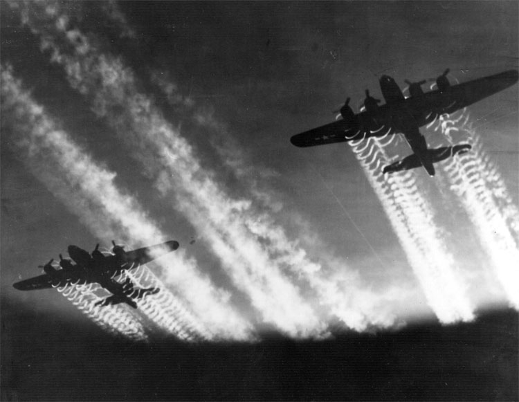
Boeing B-17F Flying Fortresses in flight with contrails
Three-quarter left front view from below of a formation of Boeing B-17F Flying Fortresses of the Eighth Air Force, 390th Bomb Group (309BG), in flight somewhere over Europe; contrails (vapor trails) made by their escort fighters curve through the sky above the formation. Wing of photographer's B-17 visible in foreground. Circa December 1943.
- Date
- 1943–1944
- Mapmaker / publisher
- Sgt. Stanley M. Smith/United States Army Air Force
- Archive
- Wikimedia Commons
- Type
- map
- Original size
- 3,000 × 2,403 pixels
Public domainsafest
Reason: a US government work (US Air Force).
Read from: Commons licence category: PD US Air Force; no CC BY, CC BY-SA, GFDL or deletion tag on the file page.
Credit line
"Boeing B-17F Flying Fortresses in flight with contrails" (1943–1944). Sgt. Stanley M. Smith/United States Army Air Force, via Wikimedia Commons. Public domain. https://commons.wikimedia.org/wiki/File:Boeing_B-17F_Flying_Fortresses_in_flight_with_contrails.jpgNeed maps for a whole project? Add Find Any Map to Claude and ask for this one by its id: 103711.
More like this

Large formation of Boeing B-17Fs of the 92nd Bomb Group
c. 1943 · Wikimedia Commons

Bomber stream
Wikimedia Commons

A formation of B-17Gs from the 340th Bombardment Squadron, 97th Bombardment Group wing their way towards Linz, Austria, while their P-38 Lightning escorts contrail above them.
1944 · Wikimedia Commons

II World War contrails
1943–1944 · Wikimedia Commons
B-17 Flying Fortress
Wikimedia Commons

RB-36H with six contrails
Wikimedia Commons

Contrails formed at high altitude
October 13, 2005 · Wikimedia Commons

F-14A Tomcats Contrails
March 6, 1987 · Wikimedia Commons