

Bitola map 1890
Pre-World War I "action map" of Monastir (Present day Bitola, Macedonia) and its environs. This map series is useful to scholars because it reflects the original pre-war toponymns in precise detail.
- Date
- c. 1890
- Mapmaker / publisher
- Artaria & Co. Publishing
- Place
- North Macedonia
- Archive
- Wikimedia Commons
- Type
- map
- Original size
- 3,560 × 4,528 pixels
Public domain
Reason: its maker died long enough ago that the copyright has expired.
This status rests on the map's publication history, as researched by Wikimedia Commons. Check it before commercial use.
Read from: Commons licence category: PD Old; no CC BY, CC BY-SA, GFDL or deletion tag on the file page.
Credit line
"Bitola map 1890" (c. 1890). Artaria & Co. Publishing, via Wikimedia Commons. Public domain. https://commons.wikimedia.org/wiki/File:Bitola_map_1890.jpgNeed maps for a whole project? Add Find Any Map to Claude and ask for this one by its id: 251771.
More like this

Monastir - 39-41
1900 · Wikimedia Commons

C. 1890 Austro-Hungarian Empire
c. 1911 · Wikimedia Commons

Christian Schools in Macedonia early 20th
1903 · Wikimedia Commons

Adrianopel - 44-42
1903 · Wikimedia Commons

Monastir Vilayet — Memalik-i Mahruse-i Shahane-ye Mahsus Mukemmel ve Mufassal Atlas
1907 · Wikimedia Commons

Prizren - 38-42
1902 · Wikimedia Commons

5 - südl Serbien, westl Bulgarien; Scheda-Karte europ Türkei
1860–1870 · Wikimedia Commons
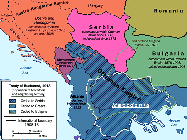
Macedonia 1913 map
1913 · Wikimedia Commons