

Battle of the Wilderness - Getty and Hancock
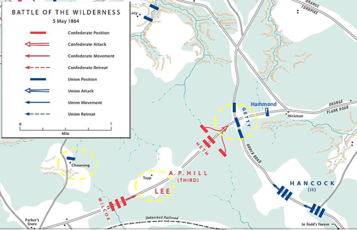
May 5 situation along the Orange Plank Road in the Battle of the Wilderness of the American Civil War. The Union command of Getty protected the vital intersection of Brock Road with Orange Plank Road while Hancock hurried to assist. Two divisions from the corps of Confederate Lieutenant General A.P. Hill advanced down Orange Plank Road, pushing back Hammond's cavalry regiment.
- Date
- 2014
- Mapmaker / publisher
- David W. Hogan, Jr. and the United States Army Center of Military History
- Archive
- Wikimedia Commons
- Type
- map
- Original size
- 713 × 381 pixels
Public domainsafest
Reason: a US government work.
Read from: Commons licence category: PD US Government; no CC BY, CC BY-SA, GFDL or deletion tag on the file page.
Credit line
"Battle of the Wilderness - Getty and Hancock" (2014). David W. Hogan, Jr. and the United States Army Center of Military History, via Wikimedia Commons. Public domain. https://commons.wikimedia.org/wiki/File:Battle_of_the_Wilderness_-_Getty_and_Hancock.pngNeed maps for a whole project? Add Find Any Map to Claude and ask for this one by its id: 1614.
More like this
Battle of the Wilderness - May 5 Orange Plank
2014 · Wikimedia Commons

WILDERNESS May5
May 3, 2016 · Wikimedia Commons

WILDERNESS May6
May 3, 2016 · Wikimedia Commons

OC03 - Movement to Battle in the Wilderness
May 3, 2016 · Wikimedia Commons

OC02 - Movements into the Wilderness
May 3, 2016 · Wikimedia Commons

The Wilderness, May 5 & 6, 1864.
1895 · Library of Congress
Wilderness VA May 2, 1864
1912 · Library of Congress

The Wilderness. (May 5-7, 1864)
1887 · Library of Congress