

Battle of Mount Sorrel - Battle Map - June 6
This map illustrates the British/Canadian positions (in brown) and the German lines (in red) on 4 June 1916, during the Battle of Mount Sorrel. The Canadians have been driven from several strong points, including Hooge north), Mount Sorrel itself (south), and most of Observatory Ridge (centre). The image is a scan of an original Canadian Corps confidential situation map held at the Canadian War Museum. The control series consists of documents that belonged to Major-General Edward Whipple Bancroft Morrison that came into the museum's possession in 1987
- Date
- June 9, 1916
- Mapmaker / publisher
- n.d
- Archive
- Wikimedia Commons
- Type
- map
- Original size
- 1,741 × 2,800 pixels
Public domain
Reason: public domain: Canada.
This status rests on the map's publication history, as researched by Wikimedia Commons. Check it before commercial use.
Read from: Commons licence category: PD Canada; no CC BY, CC BY-SA, GFDL or deletion tag on the file page.
Credit line
"Battle of Mount Sorrel - Battle Map - June 6" (June 9, 1916). n.d, via Wikimedia Commons. Public domain. https://commons.wikimedia.org/wiki/File:Battle_of_Mount_Sorrel_-_Battle_Map_-_June_6.jpgNeed maps for a whole project? Add Find Any Map to Claude and ask for this one by its id: 22493.
More like this

Battle of Mount Sorrel - Battle Map - June 6 (restored1)
1916 · Wikimedia Commons
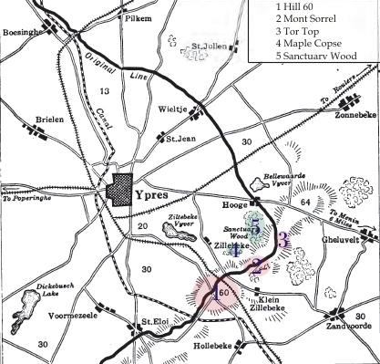
Map showing location of Battle of Mont Sorrel, Flanders, June 1916.
1919 · Wikimedia Commons

Vimy Ridge map-April 9-April 12
Wikimedia Commons

Battle of Menin Road- Australian situation map
1917 · Wikimedia Commons

Second Battle of Passchendaele map - Canadian sector - 26 October - 10 November 1917
1917 · Wikimedia Commons

Hill 70 - Map of harassing fire
1917 · Wikimedia Commons

German defensive lines, vicinity of Delville Wood, Maurepas, Morval, July-September 1916
1916 · Wikimedia Commons

DIG MZ 08729 001
June 22, 1916 · Wikimedia Commons