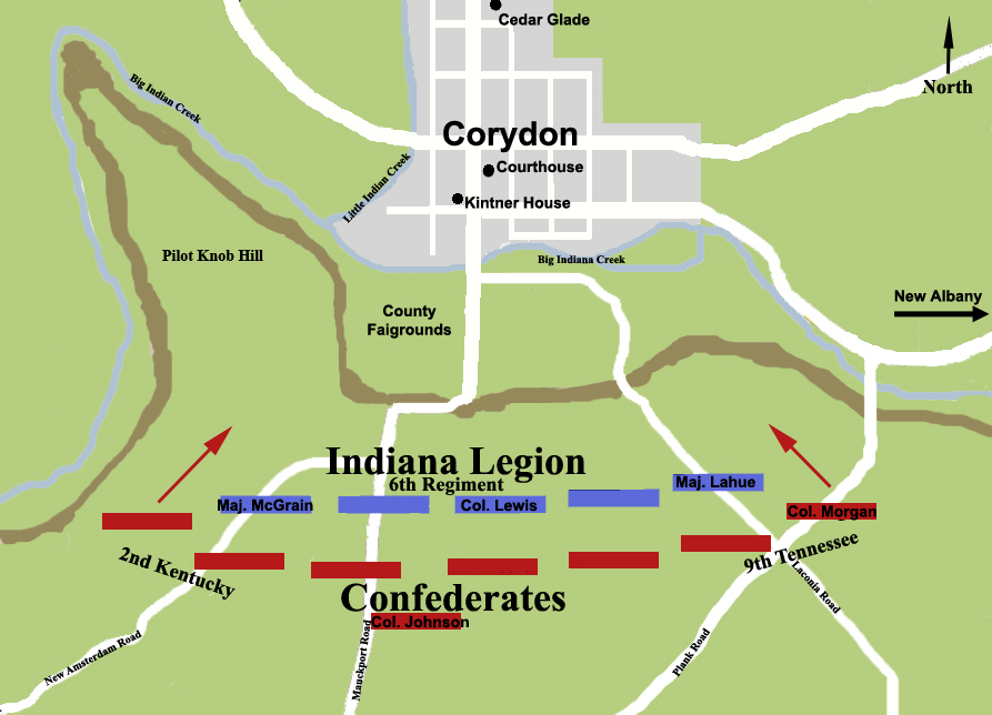

Battle of Corydon American Civil War
A map showing the battlefield at the Battle of Corydon, July 9, 1863 during the American Civil War and Corydon, Indiana. Confederate victory, 15 dead, 60 wounded. Based on a map in Funk, Arville. A Sketchbook of Indiana History. 1969. Page 88.
- Date
- March 3, 2009
- Mapmaker / publisher
- Charles Edward
- Archive
- Wikimedia Commons
- Type
- map
- Original size
- 893 × 644 pixels
Public domain
Reason: public domain: self.
This status rests on the map's publication history, as researched by Wikimedia Commons. Check it before commercial use.
Read from: Commons licence category: PD-self; no CC BY, CC BY-SA, GFDL or deletion tag on the file page.
Credit line
"Battle of Corydon American Civil War" (March 3, 2009). Charles Edward, via Wikimedia Commons. Public domain. https://commons.wikimedia.org/wiki/File:Battle_of_Corydon_American_Civil_War.jpgNeed maps for a whole project? Add Find Any Map to Claude and ask for this one by its id: 1426.
More like this

Battle of Corydon with Morgan's Raid in southern Indiana copy
November 3, 2008 · Wikimedia Commons

Corydon Battlefield Indiana
July 24, 2009 · Wikimedia Commons

Guard Hill Battlefield Virginia
July 20, 2009 · Wikimedia Commons
Corydon, Indiana: USGS topographic map, 1:62,500 (1931–1950)
1931–1950 · 5 editions

Kirksville Battlefield Missouri
April 7, 2011 · Wikimedia Commons

Kernstown I Battlefield Virginia
July 21, 2009 · Wikimedia Commons

3rd Winchester - Fort Collier
1873 · Library of Congress

3rd Winchester Map Noon
1914 · Library of Congress