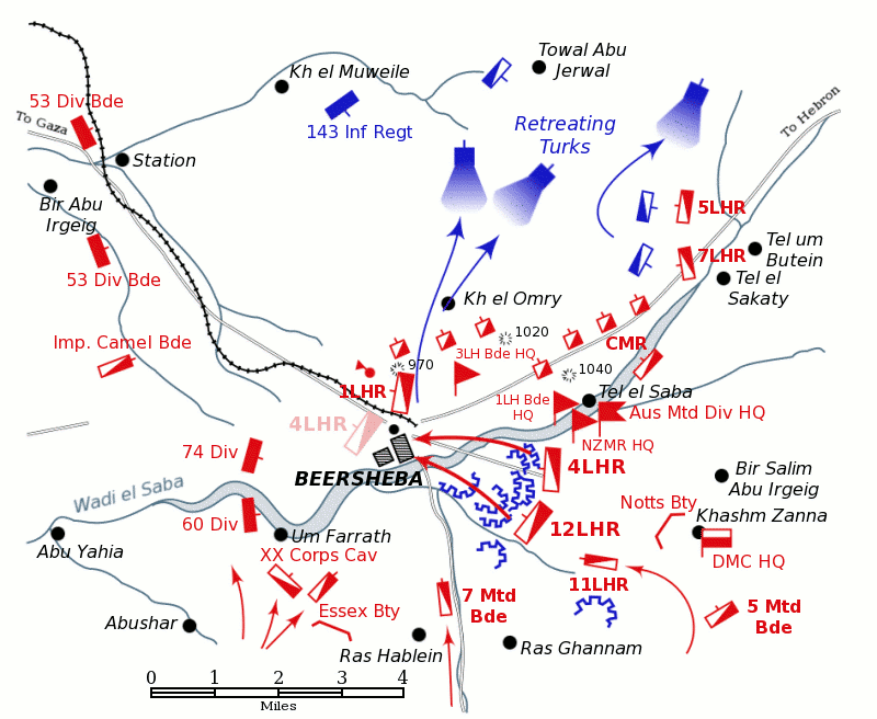

Battle of Beersheba map
Positions of forces at dusk on October 31, 1917, during the Battle of Beersheba at the time of the charge of the 4th Light Horse Brigade. British forces are shown in red, Turkish forces are shown in blue. The position reached by the regiments of the 4th Light Horse Brigade after the attack is shown in pale red. Note: there is no evidence that the 4th Light Horse Regiment crossed the Wadi Saba during their attack, nor that the 60th Division attacked south of the Wadi Saba. The Australian Mounted Division headquarters is shown where the Anzac Mounted Division headquarters moved to, after the capture of Tel el Saba. Neither the Gullett map nor Bou's map locates the headquarters of Anzac Mounted Division, Australian Mounted Division and Desert Mounted Corps at Kashim Zanna despite numemrous sources placing them there. Preston 1921 pp. 25–6, Powles 1922 pp. 136–7, Hill 1978 p. 126 See the Battle of Beersheba article for more information.
- Date
- April 12, 2004
- Mapmaker / publisher
- Originally uploaded to En Wikipedia by Gsl
- Archive
- Wikimedia Commons
- Type
- map
- Original size
- 800 × 656 pixels
Public domain
Reason: public domain: user.
This status rests on the map's publication history, as researched by Wikimedia Commons. Check it before commercial use.
Read from: Commons licence category: PD-user; no CC BY, CC BY-SA, GFDL or deletion tag on the file page.
Credit line
"Battle of Beersheba map" (April 12, 2004). Originally uploaded to En Wikipedia by Gsl, via Wikimedia Commons. Public domain. https://commons.wikimedia.org/wiki/File:Battle_of_Beersheba_map.pngNeed maps for a whole project? Add Find Any Map to Claude and ask for this one by its id: 22998.
More like this

Map of Beersheba position at dusk on 31 October 1917
1941 · Wikimedia Commons

Sketch Map of the 1st Battle of Gaza at 14:00;Other information: Australian Government publication
1917 · Wikimedia Commons

Detail of sketch map showing positions at 14:00 during First Battle of Gaza;Other information: Australian Government document
1917 · Wikimedia Commons

Sketch map of Beersheba charge in 4th Light Horse Brigade War Diary
1918 · Wikimedia Commons

Position of the mounted screen and hostile attackers at 18:00 during First Battle of Gaza;Other information: Australian Government document
1917 · Wikimedia Commons

Powles pp.112-3sit.29.10.17
1922 · Wikimedia Commons

Second Battle of Gaza map
May 8, 2004 · Wikimedia Commons

Battle of Beersheba map-HE
August 19, 2011 · Wikimedia Commons