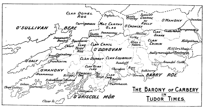

Barony of Carbery
in Tudor times
- Date
- 1904
- Mapmaker / publisher
- William Francis Thomas Butler (1869–1930)
- Place
- County Cork
- Archive
- Wikimedia Commons
- Type
- map
- Original size
- 661 × 354 pixels
Public domainsafest
Reason: its maker died more than 80 years ago.
Read from: Commons licence category: PD-old-80-expired; no CC BY, CC BY-SA, GFDL or deletion tag on the file page.
Credit line
"Barony of Carbery" (1904). William Francis Thomas Butler (1869–1930), via Wikimedia Commons. Public domain. https://commons.wikimedia.org/wiki/File:Barony_of_Carbery.pngNeed maps for a whole project? Add Find Any Map to Claude and ask for this one by its id: 245569.
More like this

Baronies of Cork
1900 · Wikimedia Commons

BAGWELL(1890) p 3.049 Munster with Adjacent Districts
1890 · Wikimedia Commons

Baronies of Kerry
1900 · Wikimedia Commons

BAGWELL(1885) p 2.168 Ireland about 1570
1885 · Wikimedia Commons

BAGWELL(1885) p 1.159 Ireland about 1500
1885 · Wikimedia Commons

BAGWELL(1890) p 3.261 Ulster with Adjacent Districts
1890 · Wikimedia Commons

To illustrate the Plantation of Leinster (Confiscation in Irish history)
1917 · Wikimedia Commons

PRENDERGAST(1870) p 451 Map of Tipperary, as divided between the Adventurers and Soldiers
1870 · Wikimedia Commons