

Antietam0850 125PA 49VA Monroe
Jubal Early attempts to protect his Brigade from shelling by Monroe's Battery by feinting with the 49th Viriginia Infantry Regiment. This image was created 100% from scratch in a CAD program while using a map from the Antietam Battlefield Board as an underlayment. The troop positions are approximated from
- Date
- May 21, 2026
- Mapmaker / publisher
- Donaldecoho
- Archive
- Wikimedia Commons
- Type
- map
- Original size
- 568 × 725 pixels
CC0safest
Reason: CC0: dedicated to the public domain.
Read from: Commons licence category: CC-Zero; no CC BY, CC BY-SA, GFDL or deletion tag on the file page.
Credit line
"Antietam0850 125PA 49VA Monroe" (May 21, 2026). Donaldecoho, via Wikimedia Commons. CC0. https://commons.wikimedia.org/wiki/File:Antietam0850_125PA_49VA_Monroe.jpgNeed maps for a whole project? Add Find Any Map to Claude and ask for this one by its id: 1270.
More like this

Troop positions at beginning of battle (not to scale)
2024 · Wikimedia Commons

The Union regiments were driven back behind two concealed regiments
August 15, 2024 · Wikimedia Commons

ATLAS BATTLEFIELD ANTIETAM ca000014 MAP10
May 29, 2016 · Library of Congress
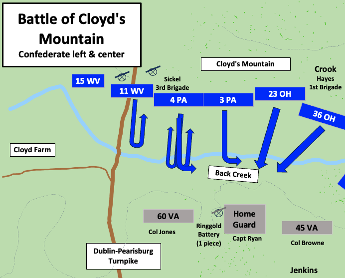
Confederate left and center when the Union attacked in the Battle of Cloyd's Mountain
August 19, 2024 · Wikimedia Commons

ATLAS BATTLEFIELD ANTIETAM ca000016 MAP12
May 29, 2016 · Library of Congress

Map of that portion of the Battle Field of Antietam occupied by the troops under Maj. Gen. Burnside, made by order of Maj. Gen. McClellan from surveys made under the supervision of Capt. R. S. Williamson, Top'l. Eng'r., on Staff of Maj. Gen. Burnside, by H. C. Fillebrown and E. S. Waters, Civ. Eng
1861–1865 · U.S. National Archives

ATLAS BATTLEFIELD ANTIETAM ca000012 MAP08
May 29, 2016 · Library of Congress

Two attacking Union regiments were driven back behind two concealed regiments
August 15, 2024 · Wikimedia Commons