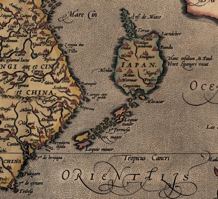

A section of a 1570 map by Abraham Ortelius
Taiwan is listed as Fermosa and is inaccurately portrayed as above the Tropic of Cancer.
- Date
- 1570
- Mapmaker / publisher
- Abraham Ortelius
- Place
- Taiwan
- Archive
- Wikimedia Commons
- Type
- map
- Original size
- 426 × 389 pixels
Public domainsafest
Reason: its maker died more than 100 years ago, and a faithful scan of a flat work adds no new copyright.
Read from: Commons licence category: PD-Art (PD-old-100); no CC BY, CC BY-SA, GFDL or deletion tag on the file page.
Credit line
"A section of a 1570 map by Abraham Ortelius" (1570). Abraham Ortelius, via Wikimedia Commons. Public domain. https://commons.wikimedia.org/wiki/File:A_section_of_a_1570_map_by_Abraham_Ortelius.jpegNeed maps for a whole project? Add Find Any Map to Claude and ask for this one by its id: 239884.
More like this

台灣地圖
Wikimedia Commons

Mapa de las islas de Taiwán (Hermosa o Formosa) y Luzón y costa de la China cercana. 01
16th century · Wikimedia Commons

Northeastern part of Ortelius Americas map from 1570. (Map showing numerous more or less anachronisticly placed mythical names on locations, as well as several phantom islands, which was regular for m
1570 · Library of Congress

1570 Map of Formosa (Taiwan) and Surrounding Countries by Flemish 佛萊明人(今比利時北部)所繪福爾摩沙臺灣
1570 · Wikimedia Commons

Abraham Ortelius turned to Mercator's world map of 1569 for his regional map of Southeast Asia. Consequently, Borneo is reduced to a narrow cigar shape and the southern coast of Java is shown, althoug
1579 · Wikimedia Commons

Map of Luzon, Isla Hermosa (Taiwan), and a Part of the Coast of China, 1597
1597 · Wikimedia Commons

1570-1612 Map of Formosa (Taiwan) and Surrounding Countries by Dutch Flemish 荷屬佛萊明人(今比利時北部)所繪福爾摩沙臺灣
1570 · Wikimedia Commons

1650 Map of Formosa (Taiwan), Philippines, Tibet, Japan, Korea, and China by Italian 義大利人所繪福爾摩沙-臺灣, 菲律賓, 中南半島, 圖博(西藏), 高麗, 日本, 與中國
1650 · Wikimedia Commons