

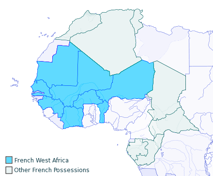
1913년 프랑스령 서아프리카 지도
- Date
- January 18, 2015
- Mapmaker / publisher
- Gusdn961020
- Place
- Africa in the 20th century
- Archive
- Wikimedia Commons
- Type
- map
- Original size
- 440 × 363 pixels
Public domain
Reason: public domain: user.
This status rests on the map's publication history, as researched by Wikimedia Commons. Check it before commercial use.
Read from: Commons licence category: PD-user; no CC BY, CC BY-SA, GFDL or deletion tag on the file page.
Credit line
"1913년 프랑스령 서아프리카 지도" (January 18, 2015). Gusdn961020, via Wikimedia Commons. Public domain. https://commons.wikimedia.org/wiki/File:1913%EB%85%84_%ED%94%84%EB%9E%91%EC%8A%A4%EB%A0%B9_%EC%84%9C%EC%95%84%ED%94%84%EB%A6%AC%EC%B9%B4_%EC%A7%80%EB%8F%84.pngNeed maps for a whole project? Add Find Any Map to Claude and ask for this one by its id: 238642.
More like this
French West Africa 1913 map
June 15, 2007 · Wikimedia Commons

Afrique occidentale française
1930 · Wikimedia Commons

French West Africa, 1958
August 18, 1958 · Wikimedia Commons

Britannica French West Africa
1911 · Wikimedia Commons

Afrique Occle Française (Divisions Administratives).
1899–1900 · Wikimedia Commons

French west africa
May 30, 2010 · Wikimedia Commons

West Africa
U.S. National Archives

Carte d'ensemble du gouvernement général de l'Afrique occidentale française et carte des étapes dressée au Service géographique de l'A. O. F.,. / sous la direction du commandant de Marlonne, d'après les renseignements fournis par l'Etat-major du Général com'supérieur
1923 · Wikimedia Commons