

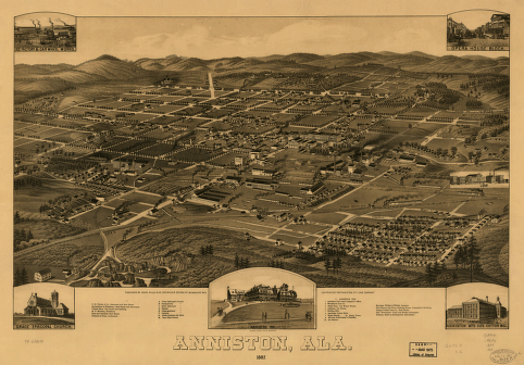
1887 Perspective Map of Anniston Alabama
This perspective/panoramic map, created by Henry Wellge, shows a bird's eye view of Anniston, Alabama in 1887. It was published by Beck & Pauli Lith. Co. and "copyrighted for 'Anniston City Land Company'". It is not drawn to scale. It contains illustrations and an index to points of interest: Grace Episcopal Church, Presbyterian Church, Methodist Church, Baptist Church, Congregational Church, Catholic Church, Noble Institute for Girls, Boys High School, Anniston City Land Company's Office, Woodstock Iron Co., Noble Bros. Car Wheel Works, Alabama Car Works, Rolling Mill, Anniston Cotton Mills, Water Works, Water Tower, Murray & Stevenson's Foundry, Ice Factory, and others.
- Date
- 1887
- Mapmaker / publisher
- Henry Wellge of Henry Wellge & Co., published by Beck & Pauli Lith. Co
- Place
- Anniston, Alabama
- Archive
- Library of Congress (via Wikimedia Commons)
- Type
- bird's-eye view
- Original size
- 7,712 × 5,376 pixels
Public domainsafest
Reason: its US copyright has expired (published before 1931).
Read from: Commons licence category: PD US expired; no CC BY, CC BY-SA, GFDL or deletion tag on the file page.
Credit line
"1887 Perspective Map of Anniston Alabama" (1887). Henry Wellge of Henry Wellge & Co., published by Beck & Pauli Lith. Co. Library of Congress, Geography and Map Division, via Wikimedia Commons. Public domain. https://commons.wikimedia.org/wiki/File:1887_Perspective_Map_of_Anniston_Alabama.jpgNeed maps for a whole project? Add Find Any Map to Claude and ask for this one by its id: 6263.
More like this
Anniston Alabama map 1887
1887 · Library of Congress

Anniston, Ala. 1887.
1887 · Library of Congress

Anniston Alabama map 1888
1888 · Library of Congress

Bird's eye view of Anniston, Ala. 1888.
1888 · Library of Congress

Anniston Alabama map 1903
c. 1903 · Library of Congress

Bird's eye view looking northwest, city of Anniston, Calhoun County, Alabama.
1903 · Library of Congress

Perspective map of the city of Gadsden, Ala. county seat of Etowah County 1887.
1887 · Library of Congress

Gadsden, AL - Perspective Map - 1887
1887 · Library of Congress