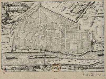

1634-Plan d'Orléans
1634 map of Orléans
- Date
- April 30, 2012
- Mapmaker / publisher
- made in 1634
- Place
- Orléans by Braun & Hogenberg
- Archive
- Wikimedia Commons
- Type
- map
- Original size
- 402 × 300 pixels
Public domain
Reason: a US government work.
This status rests on the map's publication history, as researched by Wikimedia Commons. Check it before commercial use.
Read from: Commons licence category: PD US; no CC BY, CC BY-SA, GFDL or deletion tag on the file page; Commons tags it as a US government work, but its record names no government maker.
Credit line
"1634-Plan d'Orléans" (April 30, 2012). made in 1634, via Wikimedia Commons. Public domain. https://commons.wikimedia.org/wiki/File:1634-Plan_d%27Orl%C3%A9ans.JPGNeed maps for a whole project? Add Find Any Map to Claude and ask for this one by its id: 303245.
More like this

1581-Aurelia Franciae civitas ad Ligeri flu
1581–1588 · Wikimedia Commons

Civitates orbis terrarvm.
1612 · Orléans, plate 18

De praecipvis totivs Vniversi vrbibvs, liber secvndvs
Wikimedia Commons

Aurelia Franciae civitas ad Ligerim fluv. sita
1645 · Orléans, plate 1 of 2

Orléans; Aurelia Franciae civitas ad Ligeri. flu. sita / Depingebat Georgius Hoefnagle
1581 · Orléans ; Aurelia Franciae civitas ad Ligeri. flu. sita, plate 2 of 3

GOUVERNEMENT GENERAL DV PAYS ORLEANOIS
1662 · Wikimedia Commons

Contrafactur und Beschreibung von den vornembsten Stetten der Welt. Liber tertius (page 20)
1582 · Wikimedia Commons

Orléans; Bourges / Depingebat Georgius Hoefnagle
1645 · Orléans ; Bourges, plate 1 of 3